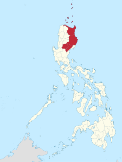
Saug Cagayan
Ing Saug Cagayan Labuad ning Luzon, Filipinas. Agpang keng 1 Mayu 2020 ning sensus, atin yang populasyun a 3,685,744 a katau kareng 789,269 a pamimalemale.
Saug Cagayan | |
|---|---|
 | |
 Mapa ning Filipinas ampong Saug Cagayan ilage | |
 | |
| Puuk: 17°37'N, 121°43'E | |
| Bansa | Filipinas |
| Labuad | Filipinas |
| Kapitolyo | Tuguegarao |
| Sukad | |
| • Kabilugan | 28,228.83 km2 (10,899.21 sq mi) |
| Populasyun (Sensu ning 1 Mayu 2020) | |
| • Kabilugan | 3,685,744 |
| • Densidad | 130/km2 (340/sq mi) |
| • Pamimalemale | 789,269 |
| Amanu | Pamplona Atta Amanung Arta Dupaningan Agta Amanung Ivatan Amanung Isnag Amanung Itawis Ilokanu Faire Atta |
Politika Pangadake
mag-edit| Province/Lakanbalen | Tungku | Populasyun (2000) |
Dagul/Lapad (km²) |
Pop. Pangasiksik (per km²) | |
|---|---|---|---|---|---|
| Batanes | Basco | 16,467 | 209.3 | 78.7 | |
| Cagayan | Tuguegarao Lakanbalen | 993,580 | 9,002.0 | 110.4 | |
| Isabela | Ilagan | 1,287,575 | 10,664.6 | 120.7 | |
| Nueva Vizcaya | Bayombong | 366,962 | 3,903.9 | 94.0 | |
| Quirino | Cabarroguis | 148,575 | 3,057.2 | 48.6 | |
Lakanbalen
mag-edit¹ Santiago Lakanbalen metung yang timawang lakanbalen.
Demograpiku
mag-edit| Taun | Pop. | ±% p.a. |
|---|---|---|
| 1903 | 295,211 | — |
| 1918 | 348,332 | +1.11% |
| 1939 | 600,151 | +2.62% |
| 1948 | 669,006 | +1.21% |
| 1960 | 1,035,750 | +3.71% |
| 1970 | 1,462,723 | +3.51% |
| 1975 | 1,665,245 | +2.63% |
| 1980 | 1,919,091 | +2.88% |
| 1990 | 2,340,545 | +2.01% |
| 1995 | 2,536,035 | +1.51% |
| 2000 | 2,813,159 | +2.25% |
| 2007 | 3,051,487 | +1.13% |
| 2010 | 3,229,163 | +2.08% |
| 2015 | 3,451,410 | +1.28% |
| 2020 | 3,685,744 | +1.30% |
| Sanggunian: Philippine Statistics Authority[1][2][3][4] | ||
Panibatan
mag-edit- ↑ Census of Population (2015). "Total Population by Province, City, Municipality and Barangay". Total Population by Province, City, Municipality and Barangay. PSA.
- ↑ Census of Population and Housing (2010). "Total Population by Province, City, Municipality and Barangay". Total Population by Province, City, Municipality and Barangay. NSO.
- ↑ Censuses of Population (1903–2007). "Table 1. Population Enumerated in Various Censuses by Province/Highly Urbanized City: 1903 to 2007". Table 1. Population Enumerated in Various Censuses by Province/Highly Urbanized City: 1903 to 2007. NSO. https://archive.org/download/PhilippinesCensusofPopulationLGUs19032007/Region%202%20Cagayan%20Valley%20Philippines%20Census%20of%20Population%201903%20-%202007.xls.
- ↑ Province of. Municipality Population Data. Local Water Utilities Administration Research Division. Retrieved on [[Disiembri 17, 2016]].
Ding suglung a palual
mag-edit- PhilAtlas.com
- Philippine Standard Geographic Code
- Local Governance Performance Management System
- What's hot, what's new, what's cool, what's not in Cagayan Valley
- cagayanvalley.com
| Labuad at Lalawigan ning Luzon | |
| Labuad Ilocos: | Ilocos Norte | Ilocos Sur | La Union | Pangasinan |
| Saug Cagayan: | Batanes | Cagayan | Isabela | Nueva Vizcaya | Quirino |
| Kalibudtarang Luzon: | Aurora | Bataan | Bulacan | Nueva Ecija | Pampanga | Tarlac | Zambales |
| CALABARZON: | Batangas | Cavite | Laguna | Quezon | Rizal |
| MIMAROPA: | Marinduque | Occidental Mindoro | Oriental Mindoro | Palawan | Romblon |
| Labuad Bicol: | Albay | Camarines Norte | Camarines Sur | Catanduanes | Masbate | Sorsogon |
| Cordillera Adm. Region: | Abra | Apayao | Benguet | Ifugao | Kalinga | Mountain Province |
| Metro Manila: | Alang lalawigan |