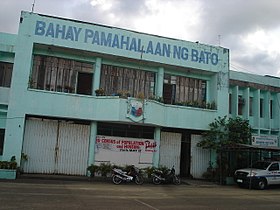
Bato, Catanduanes
Ing Balen ning Bato pang5 yang klasing balen king lalawigan ning Catanduanes, Filipinas. Agpang keng 1 Mayu 2020 ning sensus, atin yang populasyun a 21,748 a katau kareng 5,044 a pamimalemale.
Bato | |
|---|---|
 | |
 Mapa ning Catanduanes ampong Bato ilage | |
 | |
| Puuk: 13°36'N, 124°18'E | |
| Bansa | Filipinas |
| Labuad | Labuad Bicol (Rehiyong V) |
| Lalawigan | Catanduanes |
| Tuknangan | Balen |
| Mitatag | 1799 |
| Barangay | 27 |
| Sukad | |
| • Kabilugan | 48.62 km2 (18.77 sq mi) |
| Elebasyun | 156 m (512 ft) |
| Populasyun (Sensu ning 1 Mayu 2020) | |
| • Kabilugan | 21,748 |
| • Densidad | 450/km2 (1,200/sq mi) |
| • Pamimalemale | 5,044 |
| Economia | |
| • Uryan | panglima yang klasing balen |
| • Panakitan | ₱91,988,498.4939,452,134.5646,231,761.4750,727,573.9356,138,194.2962,236,498.5969,500,968.3075,031,474.0082,314,546.2397,380,235.50130,246,549.15 (2020) |
| • Activos | ₱174,157,078.1160,997,056.7066,177,320.4374,555,667.6793,039,359.74104,739,300.08135,784,731.16153,720,044.53141,238,562.85162,303,192.39177,639,215.01 (2020) |
| • Pasivos | ₱52,875,433.2420,186,909.8925,199,882.3433,697,945.3738,935,059.6941,185,855.6458,139,674.4357,427,737.9531,910,932.1918,410,843.9516,055,872.91 (2020) |
| • Gastos | ₱77,028,004.7937,931,163.4544,094,636.1349,882,333.1044,623,669.1352,768,488.5652,452,961.6260,589,185.9465,405,317.3475,134,768.8490,584,963.79 (2020) |
| Kodigo Postal | 4801 |
| PSGC | |
| IDD : area code | +63 (0)52 |
| Amanu | Southern Catanduanes Bikol Tagálug |
| Websayt | www.bato-catanduanes.gov.ph |
Deng Barangay
mag-editIng Bato atin yang 27 ng barangay.
|
|
Demograpiku
mag-edit| Taun | Pop. | ±% p.a. |
|---|---|---|
| 1903 | 8,438 | — |
| 1918 | 12,888 | +2.86% |
| 1939 | 17,230 | +1.39% |
| 1948 | 18,716 | +0.92% |
| 1960 | 13,339 | −2.78% |
| 1970 | 13,948 | +0.45% |
| 1975 | 15,415 | +2.03% |
| 1980 | 15,099 | −0.41% |
| 1990 | 15,331 | +0.15% |
| 1995 | 16,535 | +1.43% |
| 2000 | 17,761 | +1.55% |
| 2007 | 18,738 | +0.74% |
| 2010 | 19,984 | +2.37% |
| 2015 | 21,279 | +1.20% |
| 2020 | 21,748 | +0.43% |
| Sanggunian: Philippine Statistics Authority[1][2][3][4] | ||
Panibatan
mag-edit- ↑ Census of Population (2015). "Total Population by Province, City, Municipality and Barangay". Total Population by Province, City, Municipality and Barangay. PSA.
- ↑ Census of Population and Housing (2010). "Total Population by Province, City, Municipality and Barangay". Total Population by Province, City, Municipality and Barangay. NSO.
- ↑ Censuses of Population (1903–2007). "Table 1. Population Enumerated in Various Censuses by Province/Highly Urbanized City: 1903 to 2007". Table 1. Population Enumerated in Various Censuses by Province/Highly Urbanized City: 1903 to 2007. NSO. https://archive.org/download/PhilippinesCensusofPopulationLGUs19032007/Region%205%20Bicol%20Region%20Philippines%20Census%20of%20Population%201903%20-%202007.xls.
- ↑ Province of Catanduanes. Municipality Population Data. Local Water Utilities Administration Research Division. Retrieved on [[Disiembri 17, 2016]].