Tanauan, Leyte
Ing Tanauan pang3 yang klasing balen king lalawigan ning Leyte, Filipinas. Agpang keng 1 Mayu 2020 ning sensus, atin yang populasyun a 57,455 a katau kareng 14,892 a pamimalemale.
Tanauan | |
|---|---|
 | |
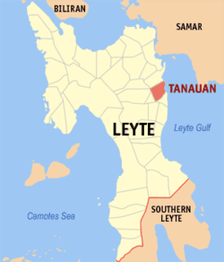
 Mapa ning Leyte ampong Tanauan ilage | |
 | |
| Puuk: 11°7'N, 125°1'E | |
| Bansa | Filipinas |
| Labuad | Aslagan Visayas (Rehiyong VIII) |
| Lalawigan | Leyte |
| Tuknangan | Balen |
| Barangay | 54 |
| Sukad | |
| • Kabilugan | 78.41 km2 (30.27 sq mi) |
| Elebasyun | 9 m (30 ft) |
| Populasyun (Sensu ning 1 Mayu 2020) | |
| • Kabilugan | 57,455 |
| • Densidad | 730/km2 (1,900/sq mi) |
| • Pamimalemale | 14,892 |
| Economia | |
| • Uryan | pangadua yang klasing balen |
| • Panakitan | ₱181,700,710.7984,869,407.1891,726,727.4498,229,544.70127,682,749.22156,433,841.44136,180,001.44151,386,956.54164,509,035.92192,371,135.71253,052,341.66 (2020) |
| • Activos | ₱598,334,065.63202,566,760.10202,182,985.06302,808,456.04367,491,202.51410,807,629.84432,700,170.14468,815,522.48524,621,130.00659,162,342.55836,947,822.06 (2020) |
| • Pasivos | ₱115,694,474.4557,654,351.6552,182,196.25132,351,705.98174,187,781.45183,698,666.01106,136,039.12104,668,985.30113,152,065.70166,435,233.2680,863,837.77 (2020) |
| • Gastos | ₱169,960,678.0491,470,464.7695,506,514.3580,560,474.70101,704,606.19111,336,577.86126,164,276.71135,876,808.41134,736,849.29155,462,416.77235,896,475.80 (2020) |
| Kodigo Postal | 6502 |
| PSGC | |
| IDD : area code | +63 (0)53 |
| Amanu | Amanung Waray Tagálug |
| Websayt | www.tanauan-leyte.gov.ph |
Deng Barangay
mag-editIng Tanauan atin yang 54 a barangay.
|
|
|
Demograpiku
mag-edit| Taun | Pop. | ±% p.a. |
|---|---|---|
| 1903 | 18,256 | — |
| 1918 | 18,880 | +0.22% |
| 1939 | 21,934 | +0.72% |
| 1948 | 24,573 | +1.27% |
| 1960 | 23,421 | −0.40% |
| 1970 | 29,438 | +2.31% |
| 1975 | 30,541 | +0.74% |
| 1980 | 31,487 | +0.61% |
| 1990 | 38,033 | +1.91% |
| 1995 | 40,716 | +1.29% |
| 2000 | 45,056 | +2.20% |
| 2007 | 47,426 | +0.71% |
| 2010 | 50,119 | +2.03% |
| 2015 | 55,021 | +1.79% |
| 2020 | 57,455 | +0.85% |
| Sanggunian: Philippine Statistics Authority[1][2][3][4] | ||
Panibatan
mag-edit- ↑ Census of Population (2015). "Total Population by Province, City, Municipality and Barangay". Total Population by Province, City, Municipality and Barangay. PSA.
- ↑ Census of Population and Housing (2010). "Total Population by Province, City, Municipality and Barangay". Total Population by Province, City, Municipality and Barangay. NSO.
- ↑ Censuses of Population (1903–2007). "Table 1. Population Enumerated in Various Censuses by Province/Highly Urbanized City: 1903 to 2007". Table 1. Population Enumerated in Various Censuses by Province/Highly Urbanized City: 1903 to 2007. NSO. https://archive.org/download/PhilippinesCensusofPopulationLGUs19032007/Region%208%20Eastern%20Visayas%20Philippines%20Census%20of%20Population%201903%20-%202007.xls.
- ↑ Province of. Municipality Population Data. Local Water Utilities Administration Research Division. Retrieved on [[Disiembri 17, 2016]].