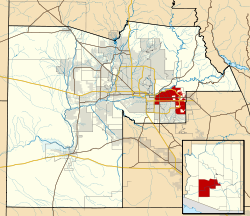
Mesa, Arizona
| Lakanbalen ning Mesa, Arizona | |||
|
|||
 |
|||
| Coordinates: | |||
|---|---|---|---|
| Bangsa | United States | ||
| State | Arizona | ||
| Counties | Maricopa | ||
| Gubyernu | |||
| - Mayor | Keno Hawker | ||
| Katas | 1,241 ft (378 m) | ||
| Populasyun (2005)[1] | |||
| - Total | 442,780 | ||
| Oras Zona | MST (no daylight saving time) (UTC-7) | ||
| Website: http://www.cityofmesa.org/ | |||
Lawen ya rin
mag-editDalerayan
mag-edit- ↑ Annual Estimates of the Population for Incorporated Places over 100,000 (CSV). 2005 Population Estimates. U.S. Census Bureau, Population Division (June 21 2006). Retrieved on November 14, 2006.
Suglung Palwal
mag-edit- Mesa city government Archived Marsu 2, 2006 at the Wayback Machine.
- City of Mesa Library on the Web Archived Agostu 27, 2006 at the Wayback Machine.
- Williams Gateway Airport.
- Mesa Storytelling Festival Annual storytelling festival in October.
- Mesa travel guide from Wikivoyage
- Mesa, Arizona is at coordinates
Template:Phoenix Metropolitan Area
| Labuad |
North Central Arizona | Northern Arizona | Phoenix metropolitan area | Southern Arizona | Arizona Strip |
|---|---|
| Counties |
Apache | Cochise | Coconino | Gila | Graham | Greenlee | La Paz | Maricopa | Mohave | Navajo | Pima | Pinal | Santa Cruz | Yavapai | Yuma |
| Pun Lakanbalen |
Chandler | Gilbert | Glendale | Mesa | Peoria | Phoenix | Scottsdale | Tempe | Tucson |
New York Lakanbalen • Los Angeles • Chicago • Houston • Philadelphia • Phoenix • San Antonio • San Diego • Dallas • San Jose • Detroit • Indianapolis • Jacksonville • San Francisco • Columbus • Austin • Memphis • Baltimore • Fort Worth • Charlotte • El Paso • Milwaukee • Seattle • Boston • Denver • Washington • Louisville • Nashville • Las Vegas • Portland • Oklahoma Lakanbalen • Tucson • Albuquerque • Long Beach • Atlanta • Fresno • Sacramento • New Orleans • Cleveland • Kansas Lakanbalen • Mesa • Virginia Beach • Omaha • Oakland • Tulsa • Miami • Honolulu • Minneapolis • Colorado Springs • Arlington • Wichita • St. Louis • Raleigh • Santa Ana • Anaheim • Tampa • Pittsburgh • Cincinnati • Toledo • Aurora • Bakersfield • Riverside • Stockton • Corpus Christi • Newark • Buffalo • Saint Paul • Anchorage • Lexington • Plano • St. Petersburg • Jersey Lakanbalen • Glendale (AZ) • Lincoln • Chandler • Henderson • Greensboro • Norfolk • Birmingham • Scottsdale • Fort Wayne • Baton Rouge • Madison • Hialeah • Chesapeake • Garland • Orlando • Rochester • Akron • Chula Vista • Lubbock • Laredo • Modesto • Durham • Reno • Fremont • Montgomery • Glendale (CA) • Shreveport • San Bernardino