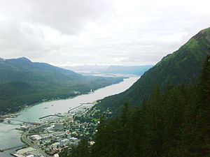
Lakanbalen ampong Borough ning Juneau, Alaska
Ing Lakanbalen ampong Borough ning Juneau (mayayagkas /ˈdʒuːnoʊ/) metung yang piabeng municipalidad atiu king Gastineau Channel king panhandle na ning U.S. state ning Alaska. Iti ing kabisera (tungku) ning Alaska manibat 1906, iniang ing gubiernu na ning kanitang-Distritu ning Alaska mialis ya manibat Sitka agpang keng dicta na ning U.S. Congress iniang 1900. Ing municipalidad piabe de iniang 1970 iniang ing lakanbalen ning Juneau miabe ya keng lakanbalen ning Douglas ampo ing makapadurut a Keragulan Juneau Borough para itatag de ing kasalungsungan a municpalidad a manungkulan.
 |
|||
|
|||
 |
|||
|
Lua error in Module:Location_map at line 501: Unable to find the specified location map definition: "Module:Location map/data/USA Alaska" does not exist.Karinan ning Juneau king state ning Alaska, United States |
|||
| Coordinates: | |||
| Bangsa | United States | ||
|---|---|---|---|
| State | Alaska | ||
| Mitatag | 1881 | ||
| Incorporated | 1890[mangailangangan yang sitas/suporta] | ||
| Gubiernu | |||
| - Mayor | Bruce Botelho | ||
| Lualas | |||
| - Lakanbalen ampong Borough | 3,255.0 sq mi (8,430.4 km2) | ||
| - Gabun | 2,715.7 sq mi (7,036.1 km2) | ||
| - Danum | 539.3 sq mi (1,394.3 km2) | ||
| - Urban | 12 sq mi (31.1 km2) | ||
| Katas/kabilian | 56 ft (17 m) | ||
| Populasiun (2008)[1] | |||
| - Lakanbalen ampong Borough | 30,988 | ||
| - Populasiun Pangasiksik | 11.3/sq mi (4.4/km2) | ||
| - Kabalenan | 17,311 | ||
| Time zone | AKST (UTC-9) | ||
| - Summer (DST) | AKDT (UTC-8) | ||
| Area code(s) | 907 | ||
| FIPS code | 02-36400 | ||
| GNIS feature ID | 1404263 | ||
| Website | www.juneau.org | ||
Klima
mag-edit| Climate chart for Juneau | |||||||||||
|---|---|---|---|---|---|---|---|---|---|---|---|
| J | F | M | A | M | J | J | A | S | O | N | D |
4.8
31
21
|
4
34
24
|
3.5
40
28
|
3
48
33
|
3.5
56
40
|
3.4
62
46
|
4.1
64
49
|
5.4
63
48
|
7.5
56
44
|
8.3
47
38
|
5.4
38
29
|
5.4
33
24
|
| average temperatures in °F precipitation totals in inches source: NOAA [2] | |||||||||||
|
Metric conversion
| |||||||||||


Mendenhall Glacier
mag-editA very popular destination is Mendenhall Glacier. A bridge connects Douglas Island with the rest of Juneau, and there are about five places where roads end. Float planes and helicopters offer glacier tours in summer. Dog sled rides are often given to tourists landing on the glaciers or ice caps. Other companies offer boat rides. One of the signature places in Juneau is The Mount Roberts Tramway, an aerial tramway stretching from a station on the cruise ship docks to a point on the southwestern ridge of Mount Roberts.
Dalerayan
mag-edit- Andrews, C.L. (1944). The Story of Alaska. The Caxton Printers, Ltd., Caldwell, Ohio.
- Naske, Claus-M and Herman E. Slotnick (1987). Alaska: A History of the 49th State. University of Oklahoma Press, Norman, Oklahoma. ISBN 0-8061-2099-1.
Suglung Palual
mag-edit- Juneau Webcams Archived Pebreru 6, 2015 at the Wayback Machine
- City and Borough of Juneau
- Visit Juneau
- Picture of Juneau and Douglas Island, 1914
- Juneau Public Libraries
- Juneau Wiki: Help your Local Wiki Grow
- National Weather Service Juneau office Archived Eneru 23, 2016 at the Wayback Machine
- JuneauWiki.org Archived Marsu 15, 2013 at the Wayback Machine
- Lakanbalen ampong Borough ning Juneau, Alaska at the Open Directory Project
| State ning Alaska | |
|---|---|
| Tungku (kabisera) | Juneau |
| Labuad | Bush Alaska - Interior - North Slope - Panhandle - South Central - Tanana Valley |
| Pekamaragul lakanbalen |
Anchorage - Barrow - Bethel - Fairbanks - Homer - Juneau - Kenai - Ketchikan - Kodiak - Kotzebue - Nome - Palmer - Petersburg - Seward - Sitka - Unalaska - Valdez - Wasilla |
| Boroughs | Aleutians East - Anchorage - Bristol Bay - Denali - Fairbanks North Star - Haines - Juneau - Kenai Peninsula - Ketchikan Gateway - Kodiak Island - Lake and Peninsula - Matanuska-Susitna - North Slope - Northwest Arctic - Sitka - Yakutat |
| Census Karinan | Aleutians West - Bethel - Dillingham - Nome - Prince of Wales-Outer Ketchikan - Skagway-Hoonah-Angoon - Southeast Fairbanks - Valdez-Cordova - Wade Hampton - Wrangell-Petersburg - Yukon-Koyukuk |
- ↑ nnual Estimates of the Resident Population for Incorporated Places in Alaska, Listed Alphabetically: April 1, 2000 to July 1, 2008 (CSV). 2008 Population Estimates. U.S. Census Bureau, Population Division (July 1, 2009). Retrieved on July 27, 2009.
- ↑ Cite error: Invalid
<ref>tag; no text was provided for refs namedNCDC
