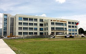
Koronadal
Ing Lakanbalen ning Koronadal dati Marbel metung yang yang lakanbalen king lalawigan ning South Cotabato, Filipinas. Agpang keng 1 Mayu 2020 ning sensus, atin yang populasyun a 195,398 a katau kareng 50,814 a pamimalemale.
Koronadal | |
|---|---|
 | |
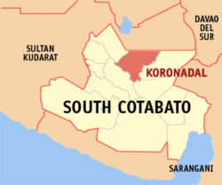
 Mapa ning Mauling Cotabato ampong Koronadal ilage | |
 | |
| Puuk: 6°30'N, 124°51'E | |
| Bansa | Filipinas |
| Labuad | Mauling Cotabato |
| Lalawigan | Mauling Cotabato |
| Tuknangan | Lakanbalen |
| Mitatag | Eneru 10, 1939 |
| Barangay | 27 |
| Sukad | |
| • Kabilugan | 277.00 km2 (106.95 sq mi) |
| Elebasyun | 333 m (1,093 ft) |
| Populasyun (Sensu ning 1 Mayu 2020) | |
| • Kabilugan | 195,398 |
| • Densidad | 710/km2 (1,800/sq mi) |
| • Pamimalemale | 50,814 |
| Economia | |
| • Uryan | pangatlu yang klasing lakanbalen |
| • Panakitan | ₱1,139,442,090.27513,608,578.37599,124,558.75626,378,611.07701,365,361.00763,736,226.00901,513,044.82915,004,331.141,084,565,555.311,211,571,169.451,618,112,903.75 (2020) |
| • Activos | ₱2,816,361,865.531,250,982,910.641,252,833,664.671,348,464,854.361,380,421,674.001,737,992,596.002,121,118,513.342,205,382,270.492,427,756,500.392,837,095,556.093,139,083,062.45 (2020) |
| • Pasivos | ₱433,034,921.62277,913,940.01225,748,239.91218,942,147.41283,830,388.90282,227,461.30372,156,992.25343,967,576.53381,849,580.40413,121,183.95496,212,279.78 (2020) |
| • Gastos | ₱1,051,570,031.52492,753,437.43467,101,674.37472,275,002.68523,405,110.00591,247,129.00647,528,524.25758,229,921.98864,095,615.661,113,158,412.231,270,836,624.89 (2020) |
| Kodigo Postal | 9506 |
| PSGC | |
| IDD : area code | +63 (0)83 |
| Amanu | Amánung Ilonggu amánung Sebuánu Maguindanao Blaan Tagálug |
| Websayt | koronadal.gov.ph |
Deng Barangay
mag-editIng Koronadal Lakanbaeln atin yang 27ng barangay.
|
|
Demograpiku
mag-edit| Taun | Pop. | ±% p.a. |
|---|---|---|
| 1918 | 13,957 | — |
| 1939 | 19,651 | +1.64% |
| 1948 | 53,563 | +11.79% |
| 1960 | 32,437 | −4.09% |
| 1970 | 54,413 | +5.30% |
| 1975 | 62,764 | +2.90% |
| 1980 | 80,566 | +5.12% |
| 1990 | 108,738 | +3.04% |
| 1995 | 118,231 | +1.58% |
| 2000 | 133,786 | +2.69% |
| 2007 | 149,622 | +1.55% |
| 2010 | 158,273 | +2.07% |
| 2015 | 174,942 | +1.93% |
| 2020 | 195,398 | +2.20% |
| Sanggunian: Philippine Statistics Authority[1][2][3][4] | ||
Panibatan
mag-edit- ↑ Census of Population (2015). "Total Population by Province, City, Municipality and Barangay". Total Population by Province, City, Municipality and Barangay. PSA.
- ↑ Census of Population and Housing (2010). "Total Population by Province, City, Municipality and Barangay". Total Population by Province, City, Municipality and Barangay. NSO.
- ↑ Censuses of Population (1903–2007). "Table 1. Population Enumerated in Various Censuses by Province/Highly Urbanized City: 1903 to 2007". Table 1. Population Enumerated in Various Censuses by Province/Highly Urbanized City: 1903 to 2007. NSO. https://archive.org/download/PhilippinesCensusofPopulationLGUs19032007/Region%2012%20Soccsksargen%20Philippines%20Census%20of%20Population%201903%20-%202007.xls.
- ↑ Province of South Cotabato. Municipality Population Data. Local Water Utilities Administration Research Division. Retrieved on [[Disiembri 17, 2016]].