Hinunangan
Ing Hinunangan pang4 yang klasing balen king lalawigan ning Mauling Leyte, Filipinas. Agpang keng 1 Mayu 2020 ning sensus, atin yang populasyun a 29,149 a katau kareng 7,402 a pamimalemale.
Hinunangan | |
|---|---|
 | |
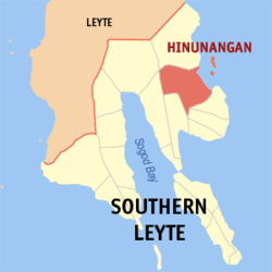
 Mapa ning Mauling Leyte ampong Hinunangan ilage | |
 | |
| Puuk: 10°24'N, 125°12'E | |
| Bansa | Filipinas |
| Labuad | Mauling Leyte |
| Lalawigan | Mauling Leyte |
| Tuknangan | Balen |
| Barangay | 40 |
| Sukad | |
| • Kabilugan | 170.58 km2 (65.86 sq mi) |
| Elebasyun | 4.8 m (15.7 ft) |
| Populasyun (Sensu ning 1 Mayu 2020) | |
| • Kabilugan | 29,149 |
| • Densidad | 170/km2 (440/sq mi) |
| • Pamimalemale | 7,402 |
| Economia | |
| • Uryan | pangatlu yang klasing balen |
| • Panakitan | ₱138,166,256.5962,202,554.4867,452,039.6380,635,620.6087,705,409.31103,591,288.805,857,048.168,295,186.95126,442,250.85151,944,928.49195,392,790.95 (2020) |
| • Activos | ₱253,993,689.45149,487,218.501,470,598.90123,327,949.03114,696,643.91144,136,711.80198,211,643.62235,240,168.73320,079,832.39380,594,761.97 (2020) |
| • Pasivos | ₱97,005,813.8883,190,192.1765,363,963.2661,390,574.2370,713,618.9266,571,934.6781,806,359.3585,061,521.7791,647,517.30127,495,631.59125,420,942.40 (2020) |
| • Gastos | ₱135,991,603.39102,144,873.9064,267,280.2272,626,619.7582,839,067.9780,265,433.8982,652,684.0086,962,971.24114,662,968.79130,146,507.09157,981,912.50 (2020) |
| Kodigo Postal | 6608 |
| PSGC | |
| IDD : area code | +63 (0)53 |
| Amanu | Boholano dialect amánung Sebuánu Tagálug |
Deng Barangay
mag-editIng Hinunangan atin yang 40ng barangay.
|
|
|
Demograpiku
mag-edit| Taun | Pop. | ±% p.a. |
|---|---|---|
| 1903 | 8,574 | — |
| 1918 | 11,491 | +1.97% |
| 1939 | 16,983 | +1.88% |
| 1948 | 17,556 | +0.37% |
| 1960 | 12,665 | −2.68% |
| 1970 | 16,142 | +2.45% |
| 1975 | 18,648 | +2.94% |
| 1980 | 20,568 | +1.98% |
| 1990 | 22,454 | +0.88% |
| 1995 | 22,170 | −0.24% |
| 2000 | 25,016 | +2.62% |
| 2007 | 27,712 | +1.42% |
| 2010 | 28,415 | +0.92% |
| 2015 | 29,976 | +1.02% |
| 2020 | 29,149 | −0.55% |
| Sanggunian: Philippine Statistics Authority[1][2][3][4] | ||
Panibatan
mag-edit- ↑ Census of Population (2015). "Total Population by Province, City, Municipality and Barangay". Total Population by Province, City, Municipality and Barangay. PSA.
- ↑ Census of Population and Housing (2010). "Total Population by Province, City, Municipality and Barangay". Total Population by Province, City, Municipality and Barangay. NSO.
- ↑ Censuses of Population (1903–2007). "Table 1. Population Enumerated in Various Censuses by Province/Highly Urbanized City: 1903 to 2007". Table 1. Population Enumerated in Various Censuses by Province/Highly Urbanized City: 1903 to 2007. NSO. https://archive.org/download/PhilippinesCensusofPopulationLGUs19032007/Region%208%20Eastern%20Visayas%20Philippines%20Census%20of%20Population%201903%20-%202007.xls.
- ↑ Province of Southern Leyte. Municipality Population Data. Local Water Utilities Administration Research Division. Retrieved on [[Disiembri 17, 2016]].