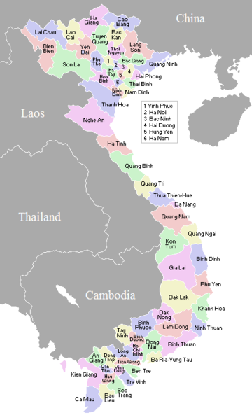
File:VietnameseProvincesMap.png

Size of this preview: 360 × 600 pixels. Other resolutions: 144 × 240 pixels | 428 × 713 pixels.
Ing minunang simpan (file) (428 × 713 pixel, sukad ning simpan: 29 KB, MIME type: image/png)
Amlat ning simpan (File history)
Mag-click kang petsa/oras ba meng akit ing itsura ning simpan aniang panaun a ita.
| Petsa/Oras | Thumbnail | Sukad | Talagamit | Komentu/Puna | |
|---|---|---|---|---|---|
| salukuyan | 02:56, 2 Nobyembri 2007 |  | 428 × 713 (29 KB) | Vietlong | Reverted to version as of 11:41, 30 August 2006 |
| 11:47, 30 Agostu 2006 |  | 428 × 713 (25 KB) | Vietlong | Reverted to earlier revision | |
| 11:41, 30 Agostu 2006 |  | 428 × 713 (29 KB) | Vietlong | Correcting the boundary between Lai Chau and Lao Cai provinces | |
| 21:58, 20 Eneru 2006 |  | 428 × 713 (25 KB) | Vardion | correcting boundary between Dien Bien and Lai Chau provinces | |
| 05:55, 18 Abril 2005 |  | 428 × 713 (25 KB) | Vardion | fixing error | |
| 07:17, 17 Marsu 2005 |  | 428 × 713 (25 KB) | Waerth | {{PD}} |
↓Suglung kareng simpan (''file links'')
Ing tutuking page links kaniting simpan (file):
Global file usage
The following other wikis use this file:
- Usage on ace.wikipedia.org
- Usage on ar.wikipedia.org
- Usage on ba.wikipedia.org
- Usage on bg.wiktionary.org
- Usage on blk.wikipedia.org
- Usage on bn.wikipedia.org
- Usage on ca.wikipedia.org
- Usage on ce.wikipedia.org
- Usage on da.wikipedia.org
- Usage on en.wikipedia.org
- Usage on fi.wikipedia.org
- Usage on gl.wikipedia.org
- Usage on id.wikipedia.org
- Usage on it.wikipedia.org
- Usage on kk.wikipedia.org
- Usage on krc.wikipedia.org
- Usage on kv.wikipedia.org
- Usage on lt.wikipedia.org
- Usage on lv.wikipedia.org
- Usage on map-bms.wikipedia.org
- Usage on ms.wikipedia.org
- Usage on my.wikipedia.org
- Usage on nl.wikipedia.org
- Usage on no.wikipedia.org
- Usage on os.wikipedia.org
- Usage on pl.wikipedia.org
- Usage on pt.wikipedia.org
- Usage on roa-tara.wikipedia.org
- Usage on ru.wikipedia.org
- Usage on su.wikipedia.org
- Usage on sv.wikipedia.org
- Usage on tr.wikipedia.org
View more global usage of this file.
