File:Un-croatia.svg

Ing minunang simpan (file) (SVG file, masasabing 900 × 666 pixels, dagul ning simpan: 892 KB)
Sampulung (summary)
| Description |
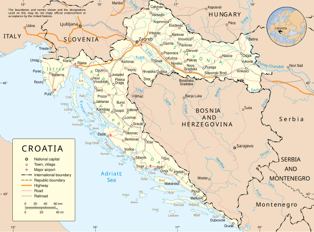
English: Map of Croatia |
| Petsa | June 2004 converted to SVG date of upload |
| Pikuanan | Derived from UN Map of Croatia converted to SVG by me |
| Maki-akda | United Nations Cartographic Section. |
| Other versions |
|


Pamamie lisensia
| This image is a map derived from a United Nations map.
Unless stated otherwise, UN maps are to be considered in the public domain. This applies worldwide. UN maps are, in principle, open source material and you can use them in your work or for making your own map. UN requests however that you delete the UN name, logo and reference number upon any modification to the map. Content of your map will be your responsibility. You can state in your publication, if you wish, something like: based on UN map … (map name, map number, revision number and date). See: Geospatial Information Section. And: Geospatial, location data for a better world. |
 |
Amlat ning simpan (File history)
Mag-click kang petsa/oras ba meng akit ing itsura ning simpan aniang panaun a ita.
| Petsa/Oras | Thumbnail | Sukad | Talagamit | Komentu/Puna | |
|---|---|---|---|---|---|
| salukuyan | 01:50, 8 Abril 2009 | | 900 × 666 (892 KB) | DooFi | According to the UN-Map-Template "the UN name and reference number should not appear on any modified map". I deleted that information from the SVG as well as the border and also fixed some more ugly kerning errors |
| 22:29, 7 Abril 2009 |  | 903 × 695 (823 KB) | DooFi | Readable resolution, fixed 'A' in "HERZEGOVINA" and very little optimization | |
| 18:30, 25 Nobyembri 2008 |  | 602 × 461 (562 KB) | RaviC | {{Information |Description={{en|Map of Croatia}} |Source=Derived from [http://www.un.org/Depts/Cartographic/map/profile/croatia.pdf UN Map of Croatia] converted to SVG by me |Author=United Nations Cartographic Section. |Date=June 2004 converted to SVG dat |
↓Suglung kareng simpan (''file links'')
Ing tutuking page links kaniting simpan (file):
Global file usage
The following other wikis use this file:
- Usage on ar.wikipedia.org
- Usage on ba.wikipedia.org
- Usage on bg.wikipedia.org
- Usage on ceb.wikipedia.org
- Usage on de.wikipedia.org
- Usage on dsb.wikipedia.org
- Usage on en.wikipedia.org
- Usage on frr.wikipedia.org
- Usage on fr.wikipedia.org
- Usage on gn.wikipedia.org
- Usage on haw.wikipedia.org
- Usage on hu.wikipedia.org
- Usage on id.wikipedia.org
- Usage on it.wikipedia.org
- Usage on ja.wikipedia.org
- Usage on jbo.wikipedia.org
- Usage on kaa.wikipedia.org
- Usage on kk.wikipedia.org
- Usage on krc.wikipedia.org
- Usage on ln.wikipedia.org
- Usage on mi.wikipedia.org
- Usage on nov.wikipedia.org
- Usage on pap.wikipedia.org
- Usage on pms.wikipedia.org
- Usage on roa-rup.wikipedia.org
- Usage on ru.wikipedia.org
- Usage on sm.wikipedia.org
- Usage on sq.wikipedia.org
- Usage on sr.wikipedia.org
- Usage on tt.wikipedia.org
- Usage on vi.wikipedia.org
- Usage on war.wikipedia.org
- Usage on wo.wikipedia.org
- Usage on zea.wikipedia.org