File:TokyoMapCurrent.png

Size of this preview: 800 × 400 pixels. Other resolutions: 320 × 160 pixels | 640 × 320 pixels | 1,280 × 640 pixels.
Ing minunang simpan (file) (1,280 × 640 pixel, sukad ning simpan: 54 KB, MIME type: image/png)

|
File:TokyoMap.svg is a vector version of this file. It should be used in place of this PNG file.
File:TokyoMapCurrent.png → File:TokyoMap.svg
For more information, see Help:SVG. |
 |
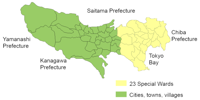
English: Map of mainland portion of Tokyo showing neighboring prefectures and Tokyo Bay
Deutsch: Karte der Präfektur Tokio, Gelb: die 23 Sonderbezirke; Grün: umliegende Gemeinden
Thanks to Aoki Shigenobu and [1]
Other versions:
- Italian: Image:TokyoMapCurrent it.png

|
Shigenobu AOKI, the copyright holder of this work, allows anyone to use it for any purpose including unrestricted redistribution, commercial use, and modification.
|
Amlat ning simpan (File history)
Mag-click kang petsa/oras ba meng akit ing itsura ning simpan aniang panaun a ita.
| Petsa/Oras | Thumbnail | Sukad | Talagamit | Komentu/Puna | |
|---|---|---|---|---|---|
| salukuyan | 20:29, 23 Setyembri 2006 | | 1,280 × 640 (54 KB) | JR98664 | |
| 01:55, 24 Abril 2005 |  | 1,440 × 801 (43 KB) | Fg2 | Replaced color in key | |
| 11:52, 23 Abril 2005 |  | 1,440 × 801 (43 KB) | Fg2 |
↓Suglung kareng simpan (''file links'')
Alang bulung a pakasuglung king simpan (file) a ini.
Global file usage
The following other wikis use this file:
- Usage on en.wikipedia.org