File:SanNicolas,Pangasinanjf9111 11.JPG

Size of this preview: 800 × 600 pixels. Other resolutions: 320 × 240 pixels | 640 × 480 pixels | 1,024 × 768 pixels | 1,280 × 960 pixels | 2,560 × 1,920 pixels | 4,608 × 3,456 pixels.
Ing minunang simpan (file) (4,608 × 3,456 pixel, sukad ning simpan: 6.41 MB, MIME type: image/jpeg)
Sampulung (summary)
| Description |
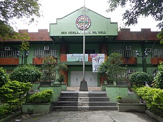
English: Municipal Hall Complex of San Nicolas, Pangasinan San Nicolas-Santa Fe Road (San Nicolas) Tayug-San Nicolas Road (San Nicolas) to San Nicolas-Natividad Road to San Nicolas-Santa Fe Road to Villaverde, Nueva Vizcaya from Santa Maria-Tayug Road to Rosales-Santa Maria Road surrounded by Caraballo Mountains and served by the Agno River, Category:Sitios and puroks of the Philippines List of barangays in Pangasinan, Barangays of Pangasinan, Barangay Legaspi, Tayug, Pangasinan 16.0476, 120.7403 Tayug, Pangasinan bounded by Category:Sitios and puroks of the Philippines List of barangays in Pangasinan, Barangays of Pangasinan, Barangays of Pangasinan, Barangays Nagkaysa, San Nicolas, Pangasinan 16.0684, 120.7612 Casaratan, San Nicolas, Pangasinan 16.0700, 120.7571 Poblacion West, San Nicolas, Pangasinan 16.0742, 120.7564 Poblacion East, San Nicolas, Pangasinan 16.0739, 120.7622 Cabitnongan, San Nicolas, Pangasinan 16.0767, 120.7709 Calaocan, San Nicolas, Pangasinan 16.0824, 120.7817 Santa Maria West, San Nicolas, Pangasinan 16.0968, 120.7931 Santa Maria East, San Nicolas, Pangasinan 16.1142, 120.8059 Cacabugaoan, San Nicolas, Pangasinan 16.1019, 120.8358 San Nicolas, Pangasinan accessed also from Highway from Pangasinan to Nueva Ecija Verde trail Nueva Ecija-Pangasinan Road Pangasinan-Nueva Ecija Interprovincial Road Latitude: 15°39'24.84" Longitude: 120°49'35.76" Villa Verde Road Villaverde Trail short cut linking Pangasinan to Nueva Vizcaya, specifcially linking Santa Fe, Nueva Vizcaya to the upland Barangays Malico 16.1401, 120.8284 and Fianza 16.1531, 120.8099 San Nicolas, Pangasinan accessed from or along Carmen Junction-Manat Road, KM 172+ (-289) - KM 189+250 and from MacArthur Highway (Rosales, Pangasinan section) MacArthur Highway or Manila North Road) Philippine highway network.) |
| Petsa | |
| Pikuanan | Own work |
| Maki-akda | Ramon FVelasquez |
Pamamie lisensia
I, the copyright holder of this work, hereby publish it under the following license:
This file is licensed under the Creative Commons Attribution-Share Alike 3.0 Unported license.
- You are free:
- to share – to copy, distribute and transmit the work
- to remix – to adapt the work
- Under the following conditions:
- attribution – You must give appropriate credit, provide a link to the license, and indicate if changes were made. You may do so in any reasonable manner, but not in any way that suggests the licensor endorses you or your use.
- share alike – If you remix, transform, or build upon the material, you must distribute your contributions under the same or compatible license as the original.
Amlat ning simpan (File history)
Mag-click kang petsa/oras ba meng akit ing itsura ning simpan aniang panaun a ita.
| Petsa/Oras | Thumbnail | Sukad | Talagamit | Komentu/Puna | |
|---|---|---|---|---|---|
| salukuyan | 10:59, 14 Agostu 2013 | | 4,608 × 3,456 (6.41 MB) | Ramon FVelasquez | User created page with UploadWizard |
↓Suglung kareng simpan (''file links'')
Ing tutuking page links kaniting simpan (file):
Global file usage
The following other wikis use this file:
- Usage on bcl.wikipedia.org
- Usage on cbk-zam.wikipedia.org
- Usage on fr.wikipedia.org
- Usage on ilo.wikipedia.org
- Usage on it.wikipedia.org
- Usage on ka.wikipedia.org
- Usage on ms.wikipedia.org
- Usage on pag.wikipedia.org
- Usage on pt.wikipedia.org
- Usage on tl.wikipedia.org
- Usage on www.wikidata.org