File:POLSKA mapa woj z powiatami.png
Size of this preview: 646 × 600 pixels. Other resolutions: 259 × 240 pixels | 517 × 480 pixels | 1,021 × 948 pixels.
Ing minunang simpan (file) (1,021 × 948 pixel, sukad ning simpan: 467 KB, MIME type: image/png)

|
This locator map image could be re-created using vector graphics as an SVG file. This has several advantages; see Commons:Media for cleanup for more information. If an SVG form of this image is available, please upload it and afterwards replace this template with
{{vector version available|new image name}}.
It is recommended to name the SVG file “POLSKA mapa woj z powiatami.svg”—then the template Vector version available (or Vva) does not need the new image name parameter. |
Sampulung (summary)
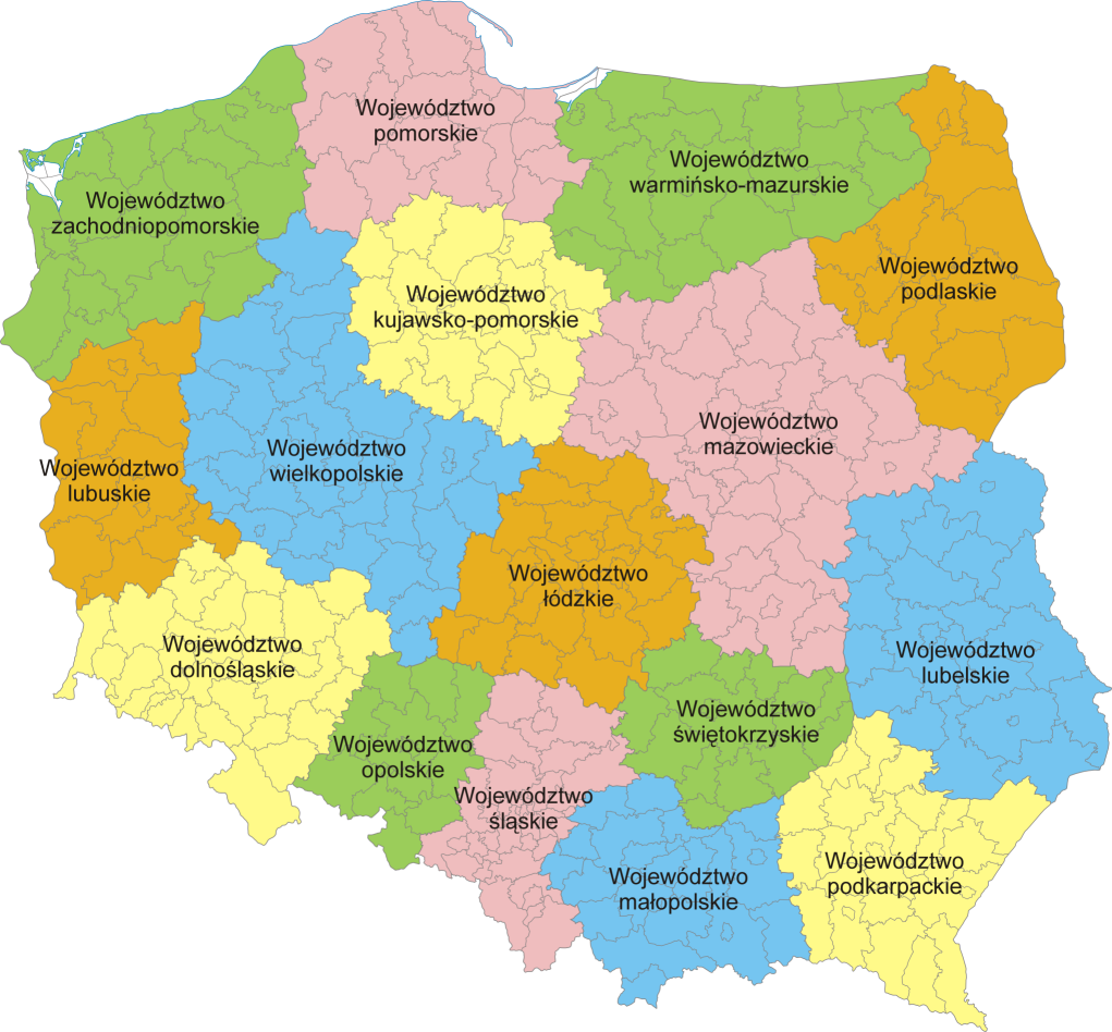
Mapa administracyjna Polski z zaznaczonymi granicami województw i powiatów, stan na 1 stycznia 2007. Autor: aç
Administrative map of Poland with borders of województwa (voivodships) and powiaty (counties), as of January 1, 2007. By Aotearoa
Pamamie lisensia
I, the copyright holder of this work, hereby publish it under the following licenses:

|
Permission is granted to copy, distribute and/or modify this document under the terms of the GNU Free Documentation License, Version 1.2 or any later version published by the Free Software Foundation; with no Invariant Sections, no Front-Cover Texts, and no Back-Cover Texts. A copy of the license is included in the section entitled GNU Free Documentation License. |
| This file is licensed under the Creative Commons Attribution-Share Alike 3.0 Unported license. | ||
| ||
| This licensing tag was added to this file as part of the GFDL licensing update. |
This file is licensed under the Creative Commons Attribution 2.5 Generic license.
- You are free:
- to share – to copy, distribute and transmit the work
- to remix – to adapt the work
- Under the following conditions:
- attribution – You must give appropriate credit, provide a link to the license, and indicate if changes were made. You may do so in any reasonable manner, but not in any way that suggests the licensor endorses you or your use.
You may select the license of your choice.
Amlat ning simpan (File history)
Mag-click kang petsa/oras ba meng akit ing itsura ning simpan aniang panaun a ita.
| Petsa/Oras | Thumbnail | Sukad | Talagamit | Komentu/Puna | |
|---|---|---|---|---|---|
| salukuyan | 20:37, 5 Pebreru 2007 | | 1,021 × 948 (467 KB) | Aotearoa | Mapa administracyjna Polski z zaznaczonymi granicami województw i powiatów, stan na 1 stycznia 2007. Autor: Aotearoa<br> Administrative map of Poland with borders of województwa (voivodships) and powiaty (counties), as of January 1, 2 |
↓Suglung kareng simpan (''file links'')
Ing tutuking page links kaniting simpan (file):
Global file usage
The following other wikis use this file:
- Usage on azb.wikipedia.org
- Usage on bs.wikipedia.org
- Usage on ca.wikipedia.org
- Usage on da.wikipedia.org
- Usage on de.wikipedia.org
- Usage on de.wikivoyage.org
- Usage on el.wikipedia.org
- Usage on en.wikipedia.org
- Usage on es.wikivoyage.org
- Usage on fa.wikipedia.org
- Usage on fr.wikipedia.org
- Usage on he.wikipedia.org
- Usage on hr.wikipedia.org
- Usage on hu.wikipedia.org
- Usage on hy.wikipedia.org
- Usage on id.wikipedia.org
- Usage on incubator.wikimedia.org
- Usage on is.wikipedia.org
- Usage on it.wikipedia.org
- Usage on lb.wikipedia.org
- Usage on ln.wikipedia.org
- Usage on mg.wikipedia.org
- Usage on ms.wikipedia.org
- Usage on mzn.wikipedia.org
- Usage on nn.wikipedia.org
- Usage on no.wikipedia.org
- Usage on pcd.wikipedia.org
- Usage on pl.wikipedia.org
View more global usage of this file.