File:My-map.png
Ala nang mas malino pa.
My-map.png (632 × 321 pixel, sukad ning simpan: 18 KB, MIME type: image/png)
Sampulung (summary)
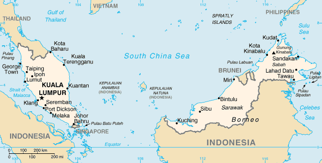
Map of Malaysia from the 2002 Factbook

Pamamie lisensia
This image is in the public domain because it contains materials that originally came from the United States Central Intelligence Agency's World Factbook.
|
 |
Amlat ning simpan (File history)
Mag-click kang petsa/oras ba meng akit ing itsura ning simpan aniang panaun a ita.
| Petsa/Oras | Thumbnail | Sukad | Talagamit | Komentu/Puna | |
|---|---|---|---|---|---|
| salukuyan | 05:15, 28 Nobyembri 2010 | | 632 × 321 (18 KB) | Ras67 | cropped |
| 15:01, 23 Setyembri 2005 |  | 635 × 325 (20 KB) | Omarete | Map of Malaysia from the 2002 Factbook {{PD-USGov-CIA-WF}} |
↓Suglung kareng simpan (''file links'')
Ing tutuking page links kaniting simpan (file):
Global file usage
The following other wikis use this file:
- Usage on ar.wikipedia.org
- Usage on be-tarask.wikipedia.org
- Usage on bn.wikipedia.org
- Usage on ca.wikipedia.org
- Usage on ckb.wikipedia.org
- Usage on diq.wikipedia.org
- Usage on en.wikipedia.org
- Usage on eo.wikipedia.org
- Usage on es.wikipedia.org
- Usage on eu.wikipedia.org
- Usage on fi.wikipedia.org
- Usage on fr.wikipedia.org
- Usage on gl.wikipedia.org
- Usage on he.wikipedia.org
- Usage on id.wikipedia.org
- Usage on incubator.wikimedia.org
- Usage on io.wikipedia.org
- Usage on it.wikipedia.org
- Usage on ja.wikipedia.org
- Usage on km.wikipedia.org
- Usage on ko.wikipedia.org
- Usage on la.wikipedia.org
- Usage on map-bms.wikipedia.org
- Usage on mr.wikipedia.org
- Usage on ms.wikipedia.org
- Usage on mwl.wikipedia.org
- Usage on nl.wikipedia.org
- Usage on no.wikipedia.org
- Usage on pa.wikipedia.org
- Usage on pl.wikipedia.org
View more global usage of this file.