File:Map Wyoming NPS sites USA.gif

Ala nang mas malino pa.
Map_Wyoming_NPS_sites_USA.gif (500 × 429 pixel, sukad ning simpan: 15 KB, MIME type: image/gif, 0.2 s)
Sampulung (summary)
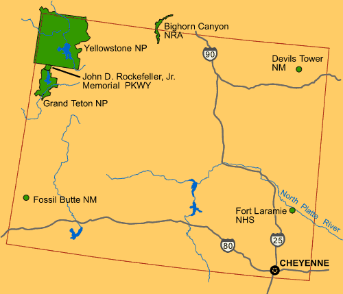
| Description | Map of Wyoming (USA), showing NPS sites of National Parks and National Landmarks: Yellowstone National Park, Grand Teton National Park, Devils Tower, etc. |
| Petsa | 26 April 2008 (uploaded) |
| Pikuanan |
From US Government website of U.S. National Park Service: |
| Maki-akda | Wikid77 (for upload) |

|
This map image could be re-created using vector graphics as an SVG file. This has several advantages; see Commons:Media for cleanup for more information. If an SVG form of this image is available, please upload it and afterwards replace this template with
{{vector version available|new image name}}.
It is recommended to name the SVG file “Map Wyoming NPS sites USA.svg”—then the template Vector version available (or Vva) does not need the new image name parameter. |
Pamamie lisensia
| This image or media file contains material based on a work of a National Park Service employee, created as part of that person's official duties. As a work of the U.S. federal government, such work is in the public domain in the United States. See the NPS website and NPS copyright policy for more information. |
Amlat ning simpan (File history)
Mag-click kang petsa/oras ba meng akit ing itsura ning simpan aniang panaun a ita.
| Petsa/Oras | Thumbnail | Sukad | Talagamit | Komentu/Puna | |
|---|---|---|---|---|---|
| salukuyan | 12:46, 26 Abril 2008 | | 500 × 429 (15 KB) | Wikid77 | initial upload {{PD-self}} |
↓Suglung kareng simpan (''file links'')
Ing tutuking page links kaniting simpan (file):
Global file usage
The following other wikis use this file:
- Usage on az.wikipedia.org
- Usage on bs.wikipedia.org
- Usage on cs.wikipedia.org
- Usage on el.wikipedia.org
- Usage on en.wikipedia.org
- Usage on fr.wikipedia.org
- Usage on hy.wikipedia.org
- Usage on is.wikipedia.org
- Usage on ja.wikipedia.org
- Usage on ml.wikipedia.org
- Usage on pl.wikipedia.org
- Usage on sl.wikipedia.org
- Usage on vi.wikipedia.org