File:Island regions of the Philippines.png
Ala nang mas malino pa.
Island_regions_of_the_Philippines.png (300 × 450 pixel, sukad ning simpan: 11 KB, MIME type: image/png)
Sampulung (summary)
| Description |
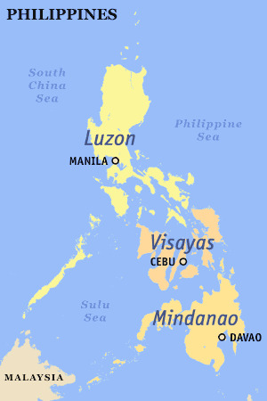
English: The island groups of the Philippines: Luzon (including Luzon proper), the Visayas, and Mindanao (including Mindanao proper).
Also labeled are the metropolitan areas. |
| Petsa | |
| Pikuanan | |
| Maki-akda | seav |
| Permission (Reusing this file) |
Released under the GFDL. |
Pamamie lisensia
seav from en.wikipedia.org, the copyright holder of this work, hereby publishes it under the following license:

|
Permission is granted to copy, distribute and/or modify this document under the terms of the GNU Free Documentation License, Version 1.2 or any later version published by the Free Software Foundation; with no Invariant Sections, no Front-Cover Texts, and no Back-Cover Texts. A copy of the license is included in the section entitled GNU Free Documentation License. |
| This file is licensed under the Creative Commons Attribution-Share Alike 3.0 Unported license. | ||
| Attribution: seav | ||
| ||
| This licensing tag was added to this file as part of the GFDL licensing update. |
Amlat ning simpan (File history)
Mag-click kang petsa/oras ba meng akit ing itsura ning simpan aniang panaun a ita.
| Petsa/Oras | Thumbnail | Sukad | Talagamit | Komentu/Puna | |
|---|---|---|---|---|---|
| salukuyan | 11:39, 15 Mayu 2019 | | 300 × 450 (11 KB) | HueMan1 | Reverted to version as of 11:37, 5 November 2005 (UTC) |
| 11:31, 15 Mayu 2019 |  | 300 × 450 (21 KB) | HueMan1 | Reverted to version as of 09:34, 24 July 2011 (UTC) | |
| 00:39, 23 Mayu 2018 |  | 300 × 450 (33 KB) | Hohum | Cartographic colours | |
| 09:34, 24 Juliu 2011 |  | 300 × 450 (21 KB) | Adikhebat | * | |
| 09:13, 24 Juliu 2011 |  | 300 × 450 (22 KB) | Adikhebat | == {{int:filedesc}} == Map of the Philippines showing Luzon, Visayas, and Mindanao. Created and copyright (2003) by seav. Released under the GFDL. == {{int:license}} == {{GFDL-user|seav|en|migration=relicense}} [[Category:Maps of i | |
| 09:12, 24 Juliu 2011 |  | 300 × 450 (22 KB) | Adikhebat | == {{int:filedesc}} == Map of the Philippines showing Luzon, Visayas, and Mindanao. Created and copyright (2003) by seav. Released under the GFDL. == {{int:license}} == {{GFDL-user|seav|en|migration=relicense}} [[Category:Maps of i | |
| 16:56, 7 Juniu 2011 |  | 300 × 450 (36 KB) | 23prootie~commonswiki | Reverting Palawan. | |
| 03:23, 15 Oktubri 2009 |  | 300 × 450 (11 KB) | Brianski | Palawan is part of Visayas according to the english wikipedia entry. | |
| 11:37, 5 Nobyembri 2005 |  | 300 × 450 (11 KB) | Magalhães | Map of the Philippines showing Luzon, Visayas, and Mindanao. Created and copyright (2003) by seav. Released under the GNU FDL. |
↓Suglung kareng simpan (''file links'')
Global file usage
The following other wikis use this file:
- Usage on ar.wikipedia.org
- Usage on azb.wikipedia.org
- Usage on az.wikipedia.org
- Usage on ba.wikipedia.org
- Usage on bcl.wikipedia.org
- Usage on be-tarask.wikipedia.org
- Usage on bjn.wikipedia.org
- Usage on bs.wikipedia.org
- Usage on ceb.wikipedia.org
- Usage on cs.wikipedia.org
- Usage on da.wikipedia.org
- Usage on de.wikinews.org
- Usage on el.wikipedia.org
- Usage on en.wikipedia.org
- Usage on es.wikipedia.org
- Usage on fa.wikipedia.org
- Usage on fi.wikipedia.org
- Usage on fr.wikipedia.org
- Usage on hi.wikipedia.org
- Usage on hr.wikipedia.org
- Usage on id.wikipedia.org
- Usage on ilo.wikipedia.org
- Usage on it.wikipedia.org
- Usage on ja.wikipedia.org
- Usage on ka.wikipedia.org
View more global usage of this file.