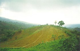
Don Victoriano Chiongbian
Ing Don Victoriano Chiongbian pang5 yang clasing balen king lalawigan ning Misamis Occidental, Filipinas. Agpang keng 1 Mayu 2020 ning sensus, atin yang populasyun a 9,664 a katau kareng 2,385 a pamimalemale.
Don Victoriano Chiongbian | |
|---|---|
 | |
 Mapa ning Misamis Occidental ampong Don Victoriano Chiongbian ilage | |
 | |
| Puuk: 8°14'58.45"N, 123°33'58.87"E | |
| Bansa | Filipinas |
| Labuad | Pangulung Mindanao (Rehiyong X) |
| Lalawigan | Misamis Occidental |
| Tuknangan | Balen |
| Barangay | 11 |
| Sukad | |
| • Kabilugan | 284.60 km2 (109.88 sq mi) |
| Elebasyun | 990 m (3,250 ft) |
| Populasyun (Sensu ning 1 Mayu 2020) | |
| • Kabilugan | 9,664 |
| • Densidad | 34/km2 (88/sq mi) |
| • Pamimalemale | 2,385 |
| Economia | |
| • Uryan | pangapat yang klasing balen |
| • Panakitan | ₱110,090,984.9147,161,648.6852,772,270.6862,245,158.6666,580,300.0073,030,437.0082,340,291.0088,537,543.0097,302,802.59118,787,260.00160,214,146.00 (2020) |
| • Activos | ₱385,990,367.77114,729,585.20127,659,798.02123,525,262.63151,151,018.00175,475,420.00271,568,494.00320,017,695.00349,290,814.38390,075,351.00530,844,059.00 (2020) |
| • Pasivos | ₱136,454,900.9132,412,512.2838,545,331.9336,432,850.0462,121,329.0072,172,849.00111,573,248.00123,953,157.00124,164,690.28101,457,062.00170,149,555.00 (2020) |
| • Gastos | ₱93,073,681.6636,691,972.7045,328,396.0143,075,795.7246,789,576.0052,012,429.0052,509,431.0055,481,143.0072,108,172.7392,226,060.00110,138,184.00 (2020) |
| Kodigo Postal | 7200 |
| PSGC | |
| IDD : area code | +63 (0)88 |
| Amanu | Subanon amánung Sebuánu Tagálug |
| Websayt | www.donvicmisocc.gov.ph |
Deng Barangay
mag-editIng Don Victoriano Chiongbian atin yang 11ng a barangay.
- Bagong Clarin
- Gandawan
- Lake Duminagat
- Lalud
- Lampasan
- Liboron
- Maramara
- Napangan
- Nueva Vista (Masawan)
- Petianan
- Tuno
Demograpiku
mag-edit| Taun | Pop. | ±% p.a. |
|---|---|---|
| 1990 | 5,803 | — |
| 1995 | 6,878 | +3.24% |
| 2000 | 9,319 | +6.73% |
| 2007 | 10,157 | +1.19% |
| 2010 | 9,774 | −1.39% |
| 2015 | 10,183 | +0.78% |
| 2020 | 9,664 | −1.02% |
| Sanggunian: Philippine Statistics Authority[1][2][3][4] | ||
Panibatan
mag-edit- ↑ Census of Population (2015). "Total Population by Province, City, Municipality and Barangay". Total Population by Province, City, Municipality and Barangay. PSA.
- ↑ Census of Population and Housing (2010). "Total Population by Province, City, Municipality and Barangay". Total Population by Province, City, Municipality and Barangay. NSO.
- ↑ Censuses of Population (1903–2007). "Table 1. Population Enumerated in Various Censuses by Province/Highly Urbanized City: 1903 to 2007". Table 1. Population Enumerated in Various Censuses by Province/Highly Urbanized City: 1903 to 2007. NSO. https://archive.org/download/PhilippinesCensusofPopulationLGUs19032007/Region%2010%20Northern%20Mindanao%20Philippines%20Census%20of%20Population%201903%20-%202007.xlsx.
- ↑ Province of Misamis Occidental. Municipality Population Data. Local Water Utilities Administration Research Division. Retrieved on [[Disiembri 17, 2016]].