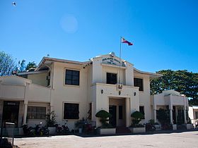
Dauin
Ing Dauin pang4 yang klasing balen ning lalawigan ning Negros Oriental, Filipinas. Agpang keng 1 Mayu 2020 ning sensus, atin yang populasyun a 30,018 a katau kareng 7,221 a pamimalemale.
Dauin | |
|---|---|
 | |
 Mapa ning Negros Oriental ampong Dauin ilage | |
 | |
| Puuk: 9°12'N, 123°16'E | |
| Bansa | Filipinas |
| Labuad | Kalibudtang Visayas (Rehiyong VII) |
| Lalawigan | Negros Oriental |
| Tuknangan | Balen |
| Barangay | 23 |
| Sukad | |
| • Kabilugan | 114.10 km2 (44.05 sq mi) |
| Elebasyun | 66 m (217 ft) |
| Populasyun (Sensu ning 1 Mayu 2020) | |
| • Kabilugan | 30,018 |
| • Densidad | 260/km2 (680/sq mi) |
| • Pamimalemale | 7,221 |
| Economia | |
| • Uryan | pangapat yang klasing balen |
| • Panakitan | ₱141,591,700.89 (2020) |
| • Activos | ₱343,106,301.59 (2020) |
| • Pasivos | ₱54,657,004.29 (2020) |
| • Gastos | ₱178,507,284.70 (2020) |
| Kodigo Postal | 6217 |
| PSGC | |
| IDD : area code | +63 (0)35 |
| Amanu | amánung Sebuánu Tagálug |
Deng Barangay
mag-editDauin is politically subdivided into 23 barangays.
|
|
Demograpiku
mag-edit| Taun | Pop. | ±% p.a. |
|---|---|---|
| 1903 | 9,224 | — |
| 1918 | 10,356 | +0.77% |
| 1939 | 12,234 | +0.80% |
| 1948 | 11,208 | −0.97% |
| 1960 | 13,175 | +1.36% |
| 1970 | 13,533 | +0.27% |
| 1975 | 14,971 | +2.05% |
| 1980 | 14,992 | +0.03% |
| 1990 | 17,513 | +1.57% |
| 1995 | 19,609 | +2.14% |
| 2000 | 21,077 | +1.56% |
| 2007 | 23,681 | +1.62% |
| 2010 | 25,239 | +2.35% |
| 2015 | 27,786 | +1.85% |
| 2020 | 30,018 | +1.53% |
| Sanggunian: Philippine Statistics Authority[1][2][3][4] | ||
Panibatan
mag-edit- ↑ Census of Population (2015). "Total Population by Province, City, Municipality and Barangay". Total Population by Province, City, Municipality and Barangay. PSA.
- ↑ Census of Population and Housing (2010). "Total Population by Province, City, Municipality and Barangay". Total Population by Province, City, Municipality and Barangay. NSO.
- ↑ Censuses of Population (1903–2007). "Table 1. Population Enumerated in Various Censuses by Province/Highly Urbanized City: 1903 to 2007". Table 1. Population Enumerated in Various Censuses by Province/Highly Urbanized City: 1903 to 2007. NSO. https://archive.org/download/PhilippinesCensusofPopulationLGUs19032007/Region%207%20Central%20Visayas%20Philippines%20Census%20of%20Population%201903%20-%202007.xlsx.
- ↑ Province of. Municipality Population Data. Local Water Utilities Administration Research Division. Retrieved on [[Disiembri 17, 2016]].