Dagohoy
Ing Dagohoy pang5 yang klasing balen king lalawigan ning Bohol, Filipinas. Agpang keng 1 Mayu 2020 ning sensus, atin yang populasyun a 19,874 a katau kareng 4,547 a pamimalemale.
Dagohoy | |
|---|---|
 | |
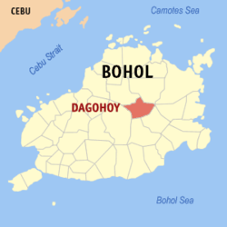
 Mapa ning Bohol ampong Dagohoy ilage | |
 | |
| Puuk: 9°55'N, 124°17'E | |
| Bansa | Filipinas |
| Labuad | Kalibudtang Visayas (Rehiyong VII) |
| Lalawigan | Bohol |
| Tuknangan | Balen |
| Mitatag | Juniu 21, 1956 |
| Barangay | 15 |
| Sukad | |
| • Kabilugan | 77.59 km2 (29.96 sq mi) |
| Elebasyun | 151 m (495 ft) |
| Populasyun (Sensu ning 1 Mayu 2020) | |
| • Kabilugan | 19,874 |
| • Densidad | 260/km2 (660/sq mi) |
| • Pamimalemale | 4,547 |
| Economia | |
| • Uryan | panglima yang klasing balen |
| • Panakitan | ₱95,640,550.5741,657,765.6346,139,173.8752,432,232.8069,380,144.17105,921,548.1091,948,885.6492,814,500.3286,628,195.83103,788,593.51133,215,526.77 (2020) |
| • Activos | ₱238,550,135.3481,532,431.18102,797,940.44108,966,658.18148,492,395.69164,362,594.00175,760,627.78204,081,413.08209,409,037.43287,607,987.18347,758,735.66 (2020) |
| • Pasivos | ₱70,691,309.1521,713,342.19334,485,084.0634,468,607.5271,081,029.2758,568,613.8864,908,020.6291,230,224.1559,004,161.0685,652,067.4693,102,430.18 (2020) |
| • Gastos | ₱113,263,196.5335,451,916.6837,954,914.0443,146,946.8257,850,589.0590,740,652.0482,353,746.9588,122,839.4780,155,277.6495,153,220.80115,204,059.62 (2020) |
| Kodigo Postal | 6322 |
| PSGC | |
| IDD : area code | +63 (0)38 |
| Amanu | Boholano dialect amánung Sebuánu Tagálug |
Deng Barangay
mag-editIng Dagohoy atin yang 15ng barangay.
- Babag
- Can-oling
- Candelaria
- Estaca
- Cagawasan
- Cagawitan
- Caluasan
- La Esperanza
- Mahayag
- Malitbog
- Poblacion
- San Miguel
- San Vicente
- Santa Cruz
- Villa Aurora
Demograpiku
mag-edit| Taun | Pop. | ±% p.a. |
|---|---|---|
| 1960 | 6,699 | — |
| 1970 | 7,291 | +0.85% |
| 1975 | 8,578 | +3.31% |
| 1980 | 9,451 | +1.96% |
| 1990 | 13,121 | +3.34% |
| 1995 | 13,943 | +1.15% |
| 2000 | 16,845 | +4.14% |
| 2007 | 18,311 | +1.16% |
| 2010 | 18,868 | +1.10% |
| 2015 | 19,158 | +0.29% |
| 2020 | 19,874 | +0.72% |
| Sanggunian: Philippine Statistics Authority[1][2][3][4] | ||
Panibatan
mag-edit- ↑ Census of Population (2015). "Total Population by Province, City, Municipality and Barangay". Total Population by Province, City, Municipality and Barangay. PSA.
- ↑ Census of Population and Housing (2010). "Total Population by Province, City, Municipality and Barangay". Total Population by Province, City, Municipality and Barangay. NSO.
- ↑ Censuses of Population (1903–2007). "Table 1. Population Enumerated in Various Censuses by Province/Highly Urbanized City: 1903 to 2007". Table 1. Population Enumerated in Various Censuses by Province/Highly Urbanized City: 1903 to 2007. NSO. https://archive.org/download/PhilippinesCensusofPopulationLGUs19032007/Region%207%20Central%20Visayas%20Philippines%20Census%20of%20Population%201903%20-%202007.xlsx.
- ↑ Province of Bohol. Municipality Population Data. Local Water Utilities Administration Research Division. Retrieved on [[Disiembri 17, 2016]].