Conques
| {{{official_name}}} |
Ing Conques metung yang commune ning Aveyron départamentu king maulingalbugan ning France.
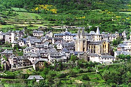
Conques View of the village and church | |
| Karinan | |
| Longitude | 02°23'50" |
| Latitude | 44°36'01" |
| Administrasyun | |
|---|---|
| Bangsa | France |
| Labuad | Midi-Pyrénées |
| Departamentu | Aveyron |
| Arrondissement | Rodez |
| Canton | Conques |
| Statistics | |
| Altitude | 221 m–663 m (avg. 442 m) |
| Lapad ning gabun¹ | 30.51 km² |
| Populasyun² (1999) |
302 |
| - Pangasiksik (1999) | 9.9/km² |
| Aliwapa | |
| INSEE/Postal code | 12076/ 12320 |
| ¹ French Land Register data, nung nu ela kayabe reng danao, pitak, pinak at glaciers > 1 km² (0.386 sq. mi. o 247 acres) at ilug estuaryo. | |
| ² Population sans doubles comptes: single count of residents of multiple communes (e.g. students and military personnel). | |


Suglung Palwal
mag-editIng Wikimedia Commons atin yang mediang maki kaugnayan kang/king: