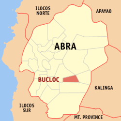
Bucloc
(Miyalis direksiun manibat king Bucloc, Abra)
Ing Bucloc metung yang pang 6 klasing balen king lalawigan ning Abra, Filipinas. Agpang keng 1 Mayu 2020 ning sensus, atin yang populasyun a 2,395 a katau kareng 480 a pamimalemale.
Bucloc | |
|---|---|
 Mapa ning Abra ampong Bucloc ilage | |
 | |
| Puuk: 17°26'N, 120°51'E | |
| Bansa | Filipinas |
| Labuad | Labuad Administratibu ning Cordillera (CAR) |
| Lalawigan | Abra |
| Tuknangan | Balen |
| Barangay | 4 |
| Sukad | |
| • Kabilugan | 63.77 km2 (24.62 sq mi) |
| Elebasyun | 601 m (1,972 ft) |
| Populasyun (Sensu ning 1 Mayu 2020) | |
| • Kabilugan | 2,395 |
| • Densidad | 38/km2 (97/sq mi) |
| • Pamimalemale | 480 |
| Economia | |
| • Uryan | panganam yang klasing balen |
| • Panakitan | ₱26,508,216.3628,735,470.0728,764,697.0938,611,444.2344,066,646.9666,976,684.9344,049,155.99 (2012) |
| • Activos | ₱25,049,805.3022,450,231.6028,548,536.1950,486,828.1391,130,510.75141,478,678.18191,888,249.13 (2012) |
| • Pasivos | ₱2,521,032.698,325,834.5112,804,127.0428,412,822.7740,384,780.4056,319,412.15103,882,982.43 (2012) |
| • Gastos | ₱30,750,298.0926,883,498.7623,289,179.5026,844,816.7328,610,672.5432,563,149.2540,162,157.72 (2012) |
| Kodigo Postal | 2817 |
| PSGC | |
| IDD : area code | +63 (0)74 |
| Amanu | Itneg Ilokanu Tagálug |
Deng Barangay
mag-editBucloc is politically subdivided into 4 barangays.
- Ducligan
- Labaan
- Lingay
- Lamao (Pob.)
Demograpiku
mag-edit| Taun | Pop. | ±% p.a. |
|---|---|---|
| 1939 | 719 | — |
| 1948 | 827 | +1.57% |
| 1960 | 1,152 | +2.80% |
| 1970 | 1,401 | +1.97% |
| 1975 | 1,447 | +0.65% |
| 1980 | 1,605 | +2.09% |
| 1990 | 1,932 | +1.87% |
| 1995 | 1,919 | −0.13% |
| 2000 | 2,109 | +2.04% |
| 2007 | 2,227 | +0.75% |
| 2010 | 2,176 | −0.84% |
| 2015 | 2,501 | +2.69% |
| 2020 | 2,395 | −0.85% |
| Sanggunian: Philippine Statistics Authority[2][3][4][5] | ||
Panibatan
mag-edit- ↑ http://nap.psa.gov.ph/activestats/psgc/province.asp?provcode=140100000.
- ↑ Census of Population (2015). "Total Population by Province, City, Municipality and Barangay". Total Population by Province, City, Municipality and Barangay. PSA.
- ↑ Census of Population and Housing (2010). "Total Population by Province, City, Municipality and Barangay". Total Population by Province, City, Municipality and Barangay. NSO.
- ↑ Censuses of Population (1903–2007). "Table 1. Population Enumerated in Various Censuses by Province/Highly Urbanized City: 1903 to 2007". Table 1. Population Enumerated in Various Censuses by Province/Highly Urbanized City: 1903 to 2007. NSO. https://archive.org/download/PhilippinesCensusofPopulationLGUs19032007/Cordillera%20CAR%20Philippines%20Census%20of%20Population%201903%20-%202007.xls.
- ↑ Province of Abra. Municipality Population Data. Local Water Utilities Administration Research Division. Retrieved on [[Disiembri 17, 2016]].