File:California map showing Lake County.png
Ala nang mas malino pa.
California_map_showing_Lake_County.png (200 × 231 pixel, sukad ning simpan: 22 KB, MIME type: image/png)
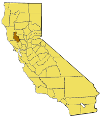
Map of Lake county in California. From en:

|
Permission is granted to copy, distribute and/or modify this document under the terms of the GNU Free Documentation License, Version 1.2 or any later version published by the Free Software Foundation; with no Invariant Sections, no Front-Cover Texts, and no Back-Cover Texts. A copy of the license is included in the section entitled GNU Free Documentation License. |
| This file is licensed under the Creative Commons Attribution-Share Alike 3.0 Unported license. | ||
| ||
| This licensing tag was added to this file as part of the GFDL licensing update. |
Amlat ning simpan (File history)
Mag-click kang petsa/oras ba meng akit ing itsura ning simpan aniang panaun a ita.
| Petsa/Oras | Thumbnail | Sukad | Talagamit | Komentu/Puna | |
|---|---|---|---|---|---|
| salukuyan | 17:03, 1 Juliu 2005 | | 200 × 231 (22 KB) | Pyramide~commonswiki | Map of Lake county in California. From en: {{GFDL}} Category:Maps of counties in California |
↓Suglung kareng simpan (''file links'')
Ing tutuking page links kaniting simpan (file):
Global file usage
The following other wikis use this file:
- Usage on bg.wikipedia.org
- Usage on en.wikipedia.org
- Stone House (Lake County, California)
- Old Lake County Courthouse (California)
- Rattlesnake Island (Clear Lake)
- Template:LakeCountyCA-geo-stub
- Forbes Creek (California)
- Clear Lake Volcanic Field
- Loch Lomond, California
- Whispering Pines, California
- Little Blue Peak
- Clearlake Highlands, California
- Buckingham Park, California
- Clearlake Park, California
- Dahnohabe, California
- Finley, California
- Glenhaven, California
- Guenoc, California
- Harbin Springs, California
- Hullville, California
- Khawina, California
- Koi, California
- Lolsel, California
- Olposel, California
- Parramore Springs
- Pine Grove, Lake County, California
- Hopitsewah, California
- Timber Lake (Lake County, California)
- Eastlake Landfill
- Great Western Mine (Lake County, California)
- Jericho Creek (Hunting Creek tributary)
- The Jams
- Seigler Canyon Creek
- Highland Springs Reservoir
- Hidden Valley Lake (California)
- Thurston Lake
- Adobe Reservoir
- Adobe Creek (Lake County, California)
- St. Helena Toll Road and Bull Trail
- Usage on li.wikipedia.org
- Usage on www.wikidata.org